On June 14th, I had just been green-lighted to attend the EsriUC, the major GIS software conference of the year. In less than 3 weeks, 15,000 geo-geeks would descend onto the San Diego Convention Center. After securing my flight, lodging and conference agenda, I did what any self-respecting ultimate player would do: check if I needed to bring my cleats. I realized that finding a game that fit my schedule would be difficult. Then a thought occurred to bring ultimate to the EsriUC in a unique way.
I decided to make a bid to create a map by utilizing two passions in my life, geography and ultimate. Professionally, I have been creating maps for the past 15 years within the GIS discipline and was introduced to the official game of ultimate 11 years ago, when I moved to the Tampa Bay area.
With the map, I wanted to showcase as many of the playing and viewing opportunities from amateur through professional that ultimate has to offer for the year 2013, since as players we can play at a weekly pickup, a hat tournament, on a college team or club team and now with one and two professional leagues.
One of the major events at the conference is the Map Gallery, which is the ‘showcase game’ of the conference. However, with late notice, I was worried about entry due to registration already being closed. The solution would be to wait in line the day of and secure a no-show’s panel.
I was pressured with less than three weeks to complete a map. Luckily, the data contributors started sending me data that first day. And as I pondered my cleats, I knew that the United States of Ultimate was going to be a crowd-pleaser. I would enter the map into the Most Unique category, which is the hardest to win but offers the most rewarding experience.
The day of the Map Gallery, I was able to reserve a panel and hung the map just before the 2pm deadline for judging. At 3:30pm the doors opened for everyone and I was overwhelmed by the positive response and large numbers of industry colleagues, who were also ultimate players or curious map aficionados.
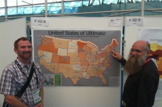
Nathaniel and Scott Morehouse, Director of Software Development at Esri, pointing to where he used to play ultimate in college
To my surprise, Scott Morehouse, Director of Software Development at Esri, came by and shared his ultimate experience of playing a co-ed pickup game every Saturday in the ’70s at Killian Court, MIT and recalled when he attended Hampshire College the only intercollegiate sport was ultimate. He added that he liked to play loose and barefoot – an aerobic form of team catch with goals to keep things motivated.
Alas, I didn’t win Most Unique but personally the map was a big winner. I’ll be wearing version 1.0 of the map as a pair of custom shorts. Next year, I’ll bring my cleats and organize a game for Esri users at Balboa Park but before then, if you are interested in enriching the ultimate community with geospatial solutions, contact me and lets work on version 2.0 of the United States of Ultimate.




Comments Policy: At Skyd, we value all legitimate contributions to the discussion of ultimate. However, please ensure your input is respectful. Hateful, slanderous, or disrespectful comments will be deleted. For grammatical, factual, and typographic errors, instead of leaving a comment, please e-mail our editors directly at editors [at] skydmagazine.com.